

Facilities requiring expansion were also common wall construction, and the EHRA team converted the facilities into aerobic digesters and sludge thickeners.
EHRA performed preliminary drainage area delineations for nine creek crossings and calculated approximate 100-year flows for each culvert crossing. Culvert structures were sized for each of the six crossings, ranging from 48” round pipe culverts up to dual 5’x5’ box culverts.
EHRA completed preliminary engineering, phase one environmental site assessment and schematic development for the widening of Northpark Dr. between US 59 and Woodland Hills Dr. EHRA also provided program management, drainage analysis and design, traffic engineering, environmental documentation and schematic design for the roadway, as well as grade separation at the Loop 494/UPRR railroad crossing.
EHRA conducted traffic operations and access management studies for the Northpark Dr. corridor. This corridor is approximately 2.2 miles long and has major signalized and unsignalized intersections and driveways that access various subdivisions and industrial developments. These studies laid the groundwork for the widening of Northpark Dr. from a four-lane boulevard cross-section to a six-lane boulevard complete street. The new street design includes low impact development drainage, conventional drainage, a grade separation at the UPRR crossing with mechanically stabilized earth retaining walls, two at-grade crossings for bi-directional frontage access, reconstruction of two concrete bridges over a diversion channel, intersection improvements, a roadway-adjacent multiuse path and traffic signal improvements.
Drainage analysis and design included hydrologic and hydraulic studies of both existing and proposed conditions to demonstrate that proposed project components would not adversely affect the 100-year floodplain in the area. The roadway and traffic designs contained horizontal and vertical alignments, cross-sections, plan and profile, sidewalk and bicycle accommodations, intersection layouts, traffic control plans and signing and pavement markings.
As the program management firm, EHRA coordinated with TxDOT, UPRR, the City of Houston Council District E, COH Planning and Development Department, COH Public Works and Engineering Department, Montgomery County, Harris County, HCFCD and area residents throughout the project.
Identified as a top priority during the development of the District’s Parks Master Plan, this portion of trail was the first phase of over two miles of planned trails to provide connectivity and recreation for District residents.
EHRA planners, hydrologists and landscape architects worked together to propose an alternative use for the space, re-developing the basin into an amenity pond. EHRA carefully selected native plant materials for both their ability to survive in the harsh conditions of the basin as well as providing filtration for improved storm water quality.
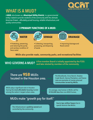
What exactly is a MUD? A Municipal Utility District (MUD) is a governmental entity created to provide residents with affordable priced housing, reliable infrastructure, and quality communities. MUD’s are composed of a five-member board, first selected by the TCEQ then later, members of the community. There are 958 MUDs in the Houston and Greater Houston area. There are 3 primary functions of a MUD: 1) water 2) sewage, and 3) drainage.
Quality Community Alliance of Texas (QCAT) offers resources to the public that educate, clarify and communicate the roles, functions and benefits of Texas utility districts, and how they enhance the quality of life for residents in their communities. EHRA is a proud to be a member of QCAT. To learn more to or to become a member of QCAT, please visit https://qcatexas.com/.